
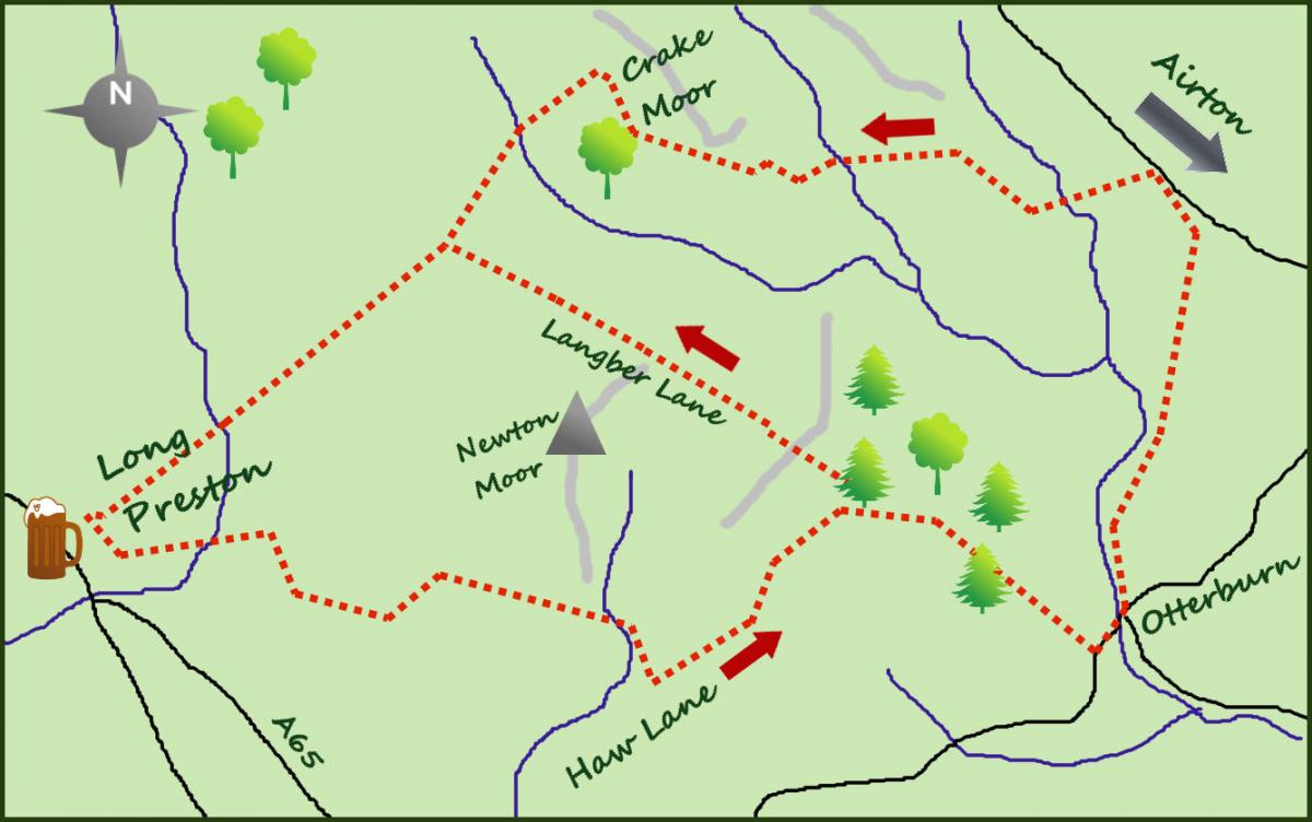
THE lands above the village are perfect, great to look at, but in addition, challenging to follow the footpaths. This is because the area from Long Preston towards Malham is rarely visited by the walker and therefore ripe for exploring. It is why I hold my beginner’s navigation courses here.
The walk starts in Long Preston at the village green. Head past the Maypole pub to the attractive primary school and follow the lane to St Mary's Church. Although the present church building "only" dates back to the early 15th century, the original place of worship dates back 900 years to Norman times. The graveyard is full of interest.
From the church head east on New House Lane for one mile to Little Newton Farm. The lane passes the lovely Long Preston Beck before you pass through a gate into the farm buildings. A small arrow points through the farm (look ahead and right) to a large solid metal gate. From the gate a farm track heads to your right (east) initially with a fence to the right, before crossing open fields to a stile on a wall and a small stream.
Cross the stream and turn right towards a gate and another lane. This is Haw Lane out of Hellifield. Turn left on the lane and climb gradually to a gate after half a mile. Leave the lane and join a signposted footpath across an open field. The path soon meets Dacre Lane with a large woodland on the opposite side of the lane. Turn right on the lane and follow it like an arrow as it drops for nearly one mile to the pretty village of Otterburn.
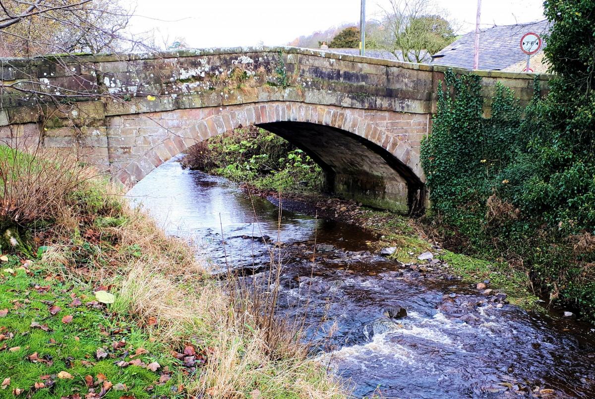
The village is prone to flooding around the stream which passes through its middle. On entering the village turn left towards the lovely pack horse road bridge. Just over the bridge turn left and pass through some wrought iron gates and a farm joining a farm track with the river on your left.
After a third of a mile, the farm track leaves the river and heads uphill. Take the track for 50 metres before it splits. Keep to the left fork and arrive at a small area of woodland. From here cross open fields with increasingly impressive views till it meets the quiet road leading out of Airton. Turn left and after 300 metres turn left again and follow a lovely farm road past attractive streams for one-and-a-half miles to Crake Moor Farm/Estate. The views to your left over open countryside are particularly impressive.
From this pleasant farm take the gate ahead and past most of the buildings and to the left which heads south west. Initially a short climb arrives at a rickety stile, cross the stile and head steeply down hill to cross a stream at a bridge. There is new woodland planted on the slopes to your right. From here follow the fence on your left to cross a stile and arrive at Bookilber Barn (a luxury cottage conversion, but very remote). From here cross the stile to the right of the building and continue south east over five stiles downhill to Long Preston Beck arriving at the small circular reservoir (supplying the village). Enjoy the views ahead over Pendle Hill. Cross the wooden bridge and continue along the land for the half mile back to the village.
Fact Box:
Distance: Roughly 9 miles
Height to Climb: 310m (1,015 feet)
Start: SD 835583. There is public parking up at the Long Preston Playing Fields, just past the school.
Difficulty: Medium/Hard. This is quite a challenging navigational route (in places) because some of the paths are, at best, intermittent on the ground.
Refreshments: The Maypole is a fine country pub in Long Preston.
Be Prepared: The route description and sketch map only provide a guide to the walk. You must take out and be able to read a map (O/S Explorer 2) and in cloudy/misty conditions a compass. You must also wear the correct clothing and footwear for the outdoors. Whilst every effort is made to provide accurate information, walkers head out at their own risk. Please observe the Countryside Code and park sensibly.
Jonathan is the owner of Where2walk, a walking company based in the Yorkshire Dales:
• He has published 3 books on walking in the Dales; ‘The Yorkshire 3 Peaks’, ‘The Dales 30’ mountains and the ‘Walks without Stiles’ book. All these books (and more) are available direct from the Where2walk website.
• Book a Navigation (Map and Compass Skills) Training day near Settle or a bespoke day for a private group. The first available day is March 23.
• Join our “Dales 30 Weekenders” in Hawes & Sedbergh.
Where2walk.co.uk also features 100s of walks across Yorkshire and beyond, from easy strolls to harder climbs.


Comments: Our rules
We want our comments to be a lively and valuable part of our community - a place where readers can debate and engage with the most important local issues. The ability to comment on our stories is a privilege, not a right, however, and that privilege may be withdrawn if it is abused or misused.
Please report any comments that break our rules.
Read the rules here