
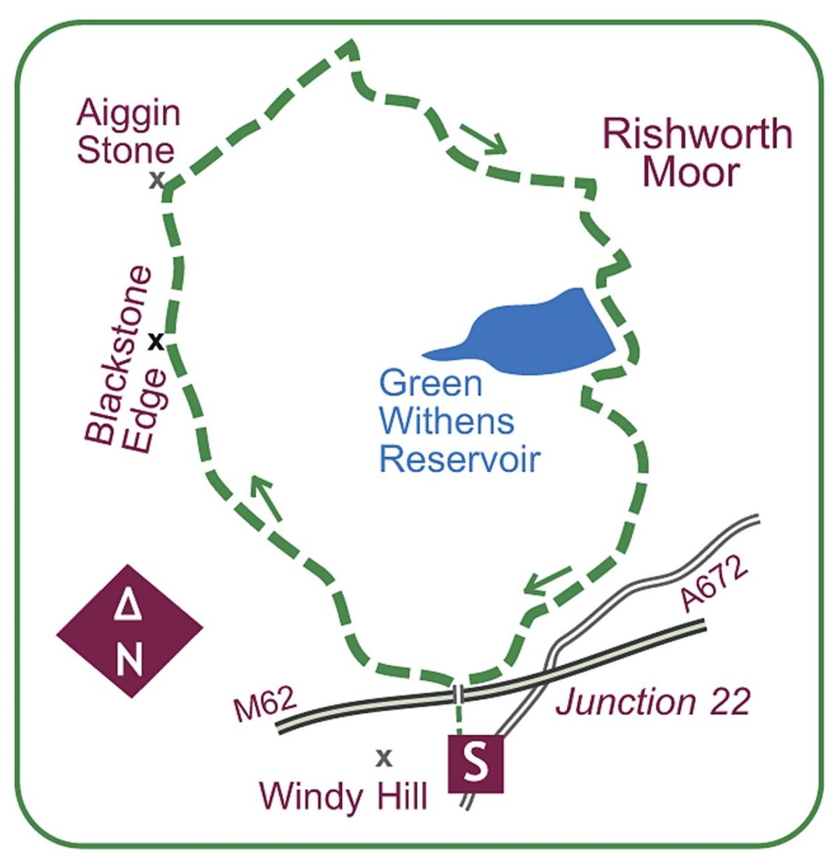
START from a parking area that you will find amid boundary signs by the large mast on A672 half-mile west of Junction 22 of the M62.
From the parking area follow the firm Pennine Way northwards, crossing the mast access road and dropping down to the M62 footbridge.
Across, bear left on the stony path rising to a cairned knoll, then on to a bridle-gate in a fence.
The path swings around to the right, and a flagstone surface makes light work of the peat bogs of Redmires.
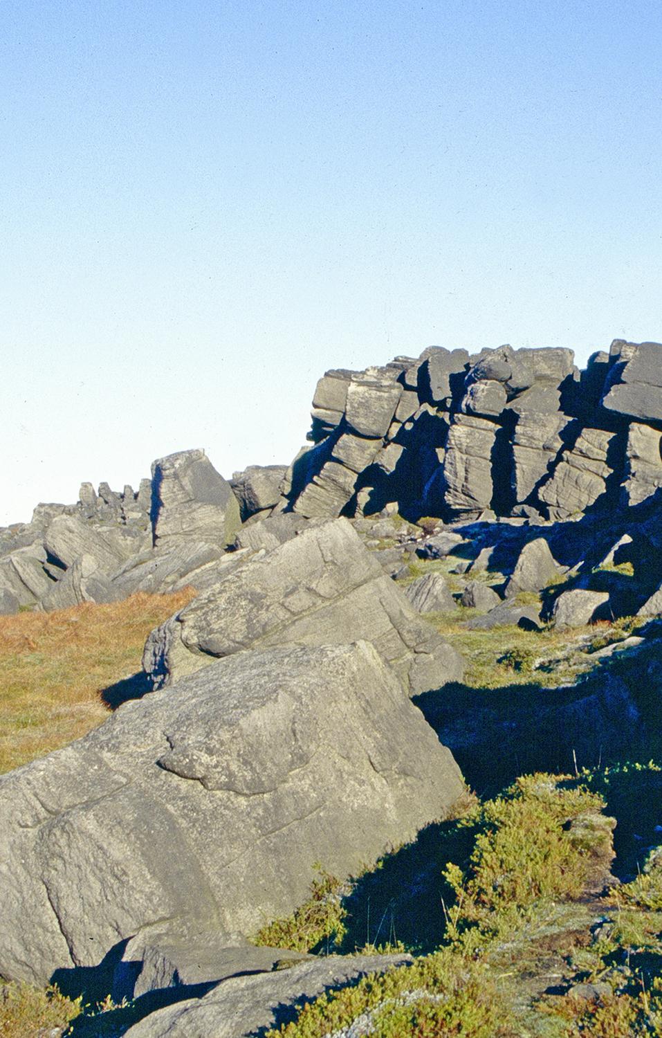
Across the head of Longden End Clough the path rises towards Blackstone Edge.
The flagstones end and Green Withens Reservoir appears down to the right.
With the bouldery crest of the edge straight ahead, the path passes a stone shelter.
The path then veers left to gain the crest between minor peat groughs.
It is now a brief stroll to the waiting Ordnance Survey column to the right.
Resume your way northwards along the edge path, soon dropping gently down.
You will leave the edge behind and follow the path running pleasantly along, to soon arrive at a bridle-gate admitting onto a path junction.
This path junction is presided over by a colourful guidepost at the historic Aiggin Stone.
Turn right, the path immediately crossing the brow and soon diverging from the fence. A gradual descent begins on a varied but clear, part-sunken way, a little peaty in parts.
The path drops to a wooden footbridge on Rishworth Drain, across which a grassy path is met. Turn right on the drain-side path, quickly curving left at a gate in the fence met earlier.
The drain runs marginally uphill to reach a ënickí in the moor. A grassy path comes in from the left, and across a drain bridge, the Rishworth Drain goes off right.
Here leave it by rising onto the minor brow in front, and bear left on a good path forming alongside another reedy drain.
The way runs on, rising gently towards Green Withens Edge. Shortly after a small, bracken-draped clough, you reach the drain’s abrupt end.
The path bears right a few paces then turns down the moor, descending alongside bracken on your left.
A guidepost at the start of a brief reedy section indicates the arrival of a lesser path from the right.
Your briefly thinner continuation bears left through the reeds to quickly improve as it crosses grassy moor to a wide bridge over a major drain.
Turn right on the broad track to quickly reach Green Withens Reservoir.
Beyond the outflow a grassy stroll shadows the dam wall above the rough road, leading around two sides to a watersports centre on the other side.
Go left on the stony drive out, again by a drain.
When the reservoir road turns off for the main road, keep right on a grassy path by the drain to its terminus at a basin under the motorway fence.
A broad path turns up its side to return you to the motorway footbridge.


Comments: Our rules
We want our comments to be a lively and valuable part of our community - a place where readers can debate and engage with the most important local issues. The ability to comment on our stories is a privilege, not a right, however, and that privilege may be withdrawn if it is abused or misused.
Please report any comments that break our rules.
Read the rules here