
Jonathan Smith runs Where2walk, a walking company in the Yorkshire Dales.
Jonathan has written his own book, the Dales 30 which details the highest mountains in the Dales.
He also runs one-day navigation courses for beginners and intermediates. Join his Learn a Skill, Climb a Hill weekends in the Dales.
To find out more details on any of the above visit his website, where2walk.co.uk
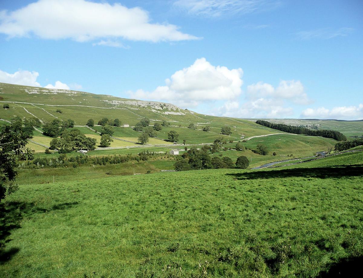
THIS is one of my favourite walks, taking in my favourite dale (Littondale) and including the pretty Malham Tarn. In between a couple of excellent tracks lead through some attractive high level limestone scenery.
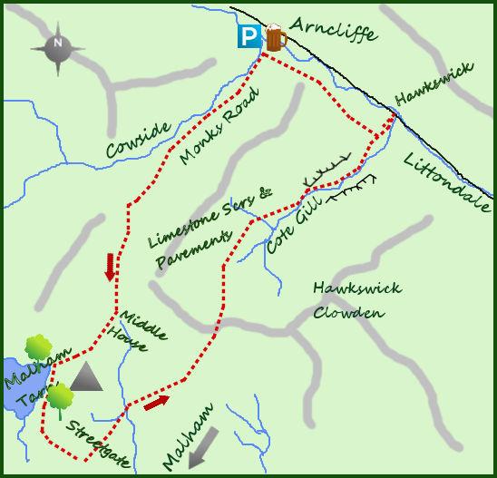
It is possible to start this walk at Malham Tarn (which can be more convenient to drive to) but I prefer the extra effort needed to leave the car in the lovely village of Arncliffe, complete with pub and attractive church. Park in near the Falcon next to the village green and head up the side road just to the east of the pub. After 200 metres where the lane bends left a footpath a well signed footpath heads directly south west up the steep hillside. This is the Monks Road. After a climb of nearly 500 feet the path levels out. The path is good as it winds its way through exposed rock whilst remaining perched over a steep valley of Cowside Beck to your right. It is a lonely place with great views particularly to the north.
After two-and-a-half miles the Monk’s Road (now a bridlepath) turns in a more southerly direction and rather surprisingly meets an isolated farm, the outbuildings and farmhouse of Middle House. The public path skirts the farm on its west side before a faint track heads in a more westerly direction (almost opposite the main building). The path heads for a wide col between two areas of higher ground. On your left is the fine viewpoint of Great Close Hill with the remains of a fort on its summit. It is worth the 20 minute detour from the col and in good weather makes a fine picnic spot and great views over Malham Tarn. Return to the col and drop down 200 feet to the banks of the tarn.
Malham Tarn lays claim to be the highest lake in England (378m) and in the past was certainly much bigger with the land on the west bank under water. It is owned and managed by the National Trust, a fine nature reserve and popular with school and student groups which visit and stay at the nearby Malham Tarn Field Studies Centre. It is a mecca for bird lovers. On meeting the path that circles the tarn turn left. The track sticks to the tarn for 200metres before bending to the south and after crossing some flat land meets a gate. Pass through the gate and take the farm track heading south east for half a mile to a quiet road. Turn left for 100 metres to the road end at Streetgate. The parking here is the alternative start point discussed earlier.
The return three-and-a-half miles to Littondale takes to the high moors on a track that generally holds a north east direction (signed to Hawkswick). After the initial half a mile the farm track comes to an awkward ad often wet gate ear a stream. Having picked your way carefully the path climbs steadily through picturesque limestone outcrops before dropping more steeply in to Littondale at the small hamlet of Hawkswick. On your right is the deep valley of Cote Gill but being perched above the gill makes for some lovely views up and down Littondale. It is easiest to return to Arncliffe by sticking to the road just before entering Hawkswick, it is little more than one mile.
Fact File
Distance: Roughly 11 miles
Height to Climb: 480m (1,580 feet)
Start: SD 931718 Park next to the green in Arncliffe.
Difficulty: Adding in Malham Tarn makes for a long day but the tracks are good and the miles fly by.
Eat and Drink: The Falcon in Arncliffe is a pub full of character.
Be Prepared:
The route description and sketch map only provide a guide to the walk. You must take out and be able to read a map (O/S Explorer OL2) and in cloudy/misty conditions a compass (essential on this walk).


Comments: Our rules
We want our comments to be a lively and valuable part of our community - a place where readers can debate and engage with the most important local issues. The ability to comment on our stories is a privilege, not a right, however, and that privilege may be withdrawn if it is abused or misused.
Please report any comments that break our rules.
Read the rules here