
Jonathan Smith runs Where2walk, a walking company in the Yorkshire Dales. Jonathan has written his own book, the Dales 30 which details the highest mountains in the Dales. He also runs one-day navigation courses for beginners and intermediates. Join his Learn a Skill, Climb a Hill weekends in the Dales. To find out more details on any of the above visit his website, where2walk.co.uk
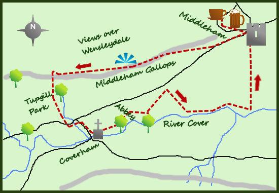
MIDDLEHAM and its wonderful castle is the base for a mid-length walk taking in great views of Wensleydale, a short section along the River Cover and interest throughout.
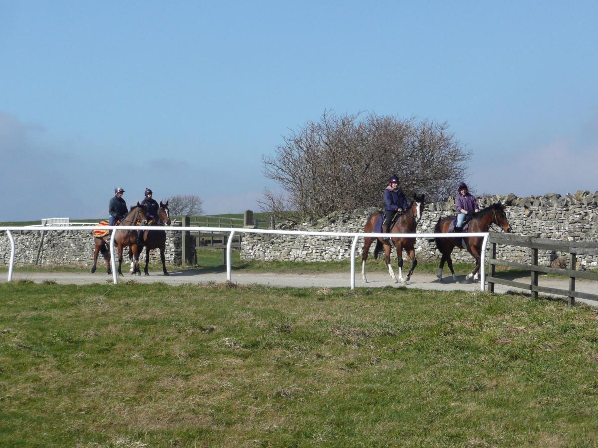
Rather than explore the castle before the walk, I tend to head out of the village on to the ‘gallops’ (a two-mile stretch of open land used by the jockeys to exercise their horses).
Even on the short climb out of the west end of Middleham before reaching the gallops, there is every chance that you will see thoroughbreds heading out. There have been racehorses bred in Middleham for 200 years but it is likely that the Cistercian Monks at nearby Jervaulx Abbey were breeding a long time before. It is part of the past and the future of the area.
Half a mile from the centre of Middleham, a footpath heads right, through a gate and on to the wide expanse of the gallops. As a walker you do tend to feel a little out of place (a bit like footpaths on golf courses) but the views of Lower Wensleydale are exceptional and on a breezy day this part of the walk is invigorating.
Having walked on relatively flat ground for 1½ miles, a track heads at right angles to the footpath. Turn south (left) and drop steadily down to Tupgill Gardens and Forbidden Corner. The gardens are excellent, but it is Forbidden Corner which makes this part of the Dales so popular. A labyrinth of follies, chambers and tunnels make up Forbidden Corner, worth visiting if you have children.
The walk carries on south through Tupgill Park, turning left at the road at its foot and then right after 500 metres in to the little hamlet of Coverham. Coverham has a lovely church and the remains of an abbey (one of the many dissolved by Henry VIII in 1536). All of these abbeys have impressive ruins and worth seeing.
From Coverham the lane bears right to the River Cover before climbing back up to the road. It is a shame that the footpath does not carry on along the river. However there is a bridlepath that cut back to the river from the road. From here follow the small area of woodland next to the river to the obvious Six Trails path leading back to Middleham. Alternatively just follow the road.
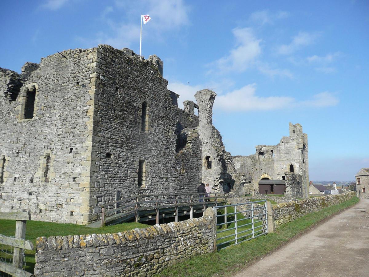
Whichever route that is taken you will arrive at the exceptional site of Middleham Castle (the Windsor of the North). This is my favourite castle in Yorkshire (Richard III thought so too) as it has the right combination of ruggedness, completeness and well situated. It somehow feels genuine to me and it is easy to picture it during its long and fascinating history. The castle is preserved impressively by English Heritage and offers a wonderful conclusion to the walk.
Fact box:
Distance: Roughly 5.5 miles.
Height to Climb: 200m (650 feet)
Start: SE 127877. There is parking in the village, just park considerately.
Difficulty: Easy/Medium. A straightforward walk on easy terrain.
Refreshments: Middleham has a choice of pubs and cafes next to its cobbled streets.
Be Prepared: The route description and sketch map only provide a guide to the walk. You must take out and be able to read a map (O/S Explorer OL26) and in cloudy/misty conditions a compass. You must also wear the correct clothing and footwear for the outdoors. Whilst every effort is made to provide accurate information, walkers head out at their own risk.
Please observe the Countryside Code and park sensibly.


Comments: Our rules
We want our comments to be a lively and valuable part of our community - a place where readers can debate and engage with the most important local issues. The ability to comment on our stories is a privilege, not a right, however, and that privilege may be withdrawn if it is abused or misused.
Please report any comments that break our rules.
Read the rules here