


Robin Longbottom examines how the mapping and marking of parish boundaries was not always an easy task
UNTIL the first Ordnance Survey of South Craven was undertaken between 1847 and 1850, there had been no accurate maps of the area.
Ordnance Survey was originally part of the military and had been established to map Scotland after the Jacobite rebellion of 1745.
It later became a separate Government agency charged with mapping the whole country.
The survey of England started in the 1790s and one task for the surveyors was to accurately record the boundaries of parishes in the south and townships in the north. This was eventually completed with astonishing accuracy and the routes of boundaries were particularly detailed. To record the boundaries the surveyors walked their length with villagers who had committed them to memory in accordance with ancient custom. Many families had been associated with the land for generations and the route was known to them by walking it in the company of older men during official ‘boundary ridings’. In the north of England, boundaries had been traditionally ridden on horseback because of the great distances often involved. The old parishes were huge, for example Kildwick parish boundary was nearly 40 miles long, but by the late Middle Ages it had been divided up into nine different townships, extending from Silsden and Steeton to Cowling and Bradley.
The surveyors devised various initials to identify the exact position of a boundary. Where one followed a watercourse, such as the River Aire, the surveyors marked it CR – if by tradition it followed the centre of the river. Along smaller becks and sikes it was marked CS, centre of stream. If the course of a river, or stream, had changed the boundary still followed the old route and marker stones were often erected and included on the new maps. In cases where a wall ran along the boundary it was generally marked FW, face of wall, to indicate which township had first built it. Boundaries along hedges were often marked RH, root of hedge, and in one case '6ft from RH' – six feet from root of hedge.
When a boundary crossed open moor, identifying the route was often more problematic and in the past was the subject of many disputes. Convenient boulders, piles of stones, standing stones (known locally as stoops) and even trees were used as markers and known as mears, or meres. During the ‘ridings’, marks such as crosses, heraldic motifs and initials were often cut into the stones. Fortunately for the surveyors many of these disputes had been settled during the period when the moors and wastes had been enclosed.
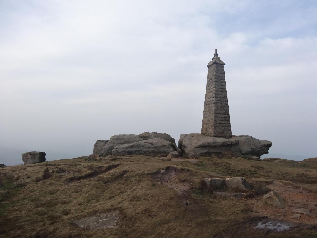
A boundary dispute between the townships of Sutton-in-Craven and Cowling ran for many years and wasn’t finally settled until Sutton Moor was enclosed. An attempt to settle the matter was made in 1797 when the freeholders of Sutton wrote to those of Stott Hill in Cowling. The letter advised that Sutton had made new marks on boulders along the line that the freeholders of Stott Hill had seen them walk in August that year. However, this failed to settle the matter and it rumbled on until 1815 when a commissioner, William Burton of Carla Beck, Carlton, was appointed to oversee the Sutton enclosure. He was shown ancient boundary marks and eventually used his statutory powers to find in favour of Sutton, which is why the monument known today as Cowling Pinnacle stands within the Sutton boundary. In cases where any doubt over a boundary remained, such as at Carlton in Craven, the map was marked 'Boundary of Carlton Moor as Perambulated in 1847'.
The first Ordnance Survey maps of Keighley and South Craven were eventually published in 1853 and brought an end to centuries of committing boundaries to memory and finally ended the disputes associated with them.


Comments: Our rules
We want our comments to be a lively and valuable part of our community - a place where readers can debate and engage with the most important local issues. The ability to comment on our stories is a privilege, not a right, however, and that privilege may be withdrawn if it is abused or misused.
Please report any comments that break our rules.
Read the rules here